The Path
of Your Dreams
From Chora Sfakion to Elafonisi Beach
FEBRUARY 28, 2023 | CRETE | 15 MIN
N 35°12'06.8"
E 24°07'02.3"
Crete

READ MORE
shape of Crete
The Mediterranean Sea in this atlas was so large that it occupied two folded pages – four pages in total, more than one and a half meters wide. At home it was difficult for me to find a table on which I could see this map in its entirety. And I’ve watched it hundreds of times. I was fascinated by the countless bays, peninsulas, separate seas, mountains rising straight out of the water and thousands of islands and islets in the eastern part. The shapes were so different, so promising and inviting; they did not resemble the dull shape of Africa, South America or Antarctica at all.
Already then I discovered Crete – not from great history and archaic culture, not from beautiful landscapes and warm sea, but from the shape on the map. It seemed so unusual to me, so different even from other Mediterranean islands: the trivial triangle of Sicily, the two almost round spots of Sardinia and Corsica, the slightly ridiculous Cyprus with its unnaturally elongated eastern tail, but Crete had a beautiful shape on my map. Unnatural – of course, how can you come up with such an elongated shape – but incredibly attractive. Sufficient number of bays and peninsulas, unexpected changes in the shape of the shoreline causing that once the island is only 12 km wide and sometimes even 60 km. From the beginning, however, it seemed great to me – almost 300 km long – it is impossible to circuit it in one day.

the great loop around
In Crete of my dreams I also had my ideal path. I didn't know where exactly it was, I didn't know what it looked like, I didn't even know if it really existed, but I was deeply convinced that if it existed, it was somewhere in Crete.
In my most optimistic dreams, I even believed that there was a great loop running along the entire coast of the island and I ran it endlessly (now I know that the coastline of my island is only 1000 km long). My fascination with Crete certainly had something to do with its location. At the very end of the Aegean Sea, closing this paradise region, the southernmost point of Europe, at the very end of my world. And if you want to run let’s do it to the very end.
Phaistos Disk

READ MORE
the path of your dreams
Now imagine that one day you discover that the path of your dreams really exists. Not only that, it exists in the mythical Crete – where you always wanted to find it. OK, maybe it’s not a thousand kilometers long, you can’t exactly run it around the entire island but it’s real. And because we usually approach the ideal slowly, my discovery of this route was gradual.
Many years after my childhood dreams, I went to Greece for the first time. By a strange twist of fate, it was Crete. I landed at the airport in Heraklion and the first place I saw was the archaeological museum, with all the treasures of the Minoan culture. It was better than any dream. Can such a world really exist? I didn’t care how much of King Minos and how much of Arthur Evans was in these masterpieces. What I saw in the museum was pure beauty. I spent a week in Crete then. I rode a bike, wandered through forgotten ravines, wandered the streets of Venetian cities, listened to the concerts of thousands of cicadas. But I had not discovered my path then. I had not even reached the regions where it is located. However, I was so captivated by my perfect island that for many years I was subconsciously afraid to go back there. You don’t want to be disappointed after you’ve seen paradise.

most beautiful path every day
But, I came back though. After spending the night in the mountains, we ran down the Aradena Gorge to the Libyan Sea. My path stretched out along the coast in both directions. Over the next few days, I discovered it in several fragments. A few hours of running in ecstasy every day. And every day a deep conviction that I am running the most beautiful path in my life. Only until the next day when I was convinced that today’s one is even more beautiful. I spent a week on the island again, so I didn’t have time to run it all. It hadn’t even crossed my mind, and I didn’t really know how to think about it. Where does this path begin, where does it end? How many kilometers do you have to run, how much time do you have to spend on it? However, it was such a strong experience that it stayed with me for years. I no longer had the slightest doubt: the path of my dreams really exists. It is located on the southwestern coast of Crete, from Chora Sfokion to Elafonisi beach and is about 75 km long. All my subsequent stays on the island of the labyrinth were counted in months, not weeks.
my first time
Finally, the moment came that I ran through all that path. In both directions at once. In October 2021, I took part in the Sfakia Sky Marathon competition. The weather that day was extremely bad, nothing could be seen, fog, rain, wind. But the next day the sun came out. The prognosis was excellent again. I didn’t think long. Since I’ve already been to Chora Sfakion where my path begins… For a moment I thought about what I’ll do when I reach Elafonisi – the logistics of traveling by bus ( by anything) from the famous beach to Chora Sfakion is a bit breakneck, especially in early November, completely out of season. “I will run back exactly the same route!” – in relation to any other path, such a thought would not have occurred to me, but in the case of this one, I had no doubts. Yes, I want to do it!
I ran for five days. From dawn to dusk on the move, at night sleep where the final darkness found me, often almost in the middle of the path. I was delighted. Every day in ecstasy from sunrise to sunset – as the poet says. The sign of madness can be the thought that came to my mind when I was approaching the finishing point on the fifth day: how about doing a turn back the next day and running the entire route again in both directions?
After that, I managed to run shorter sections of this route a few more times, but it’s not the same.


Seal Of Pylos
Forgotten Masterpiece

READ MORE
running with Helen
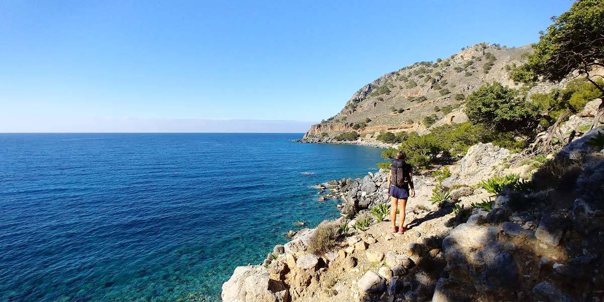
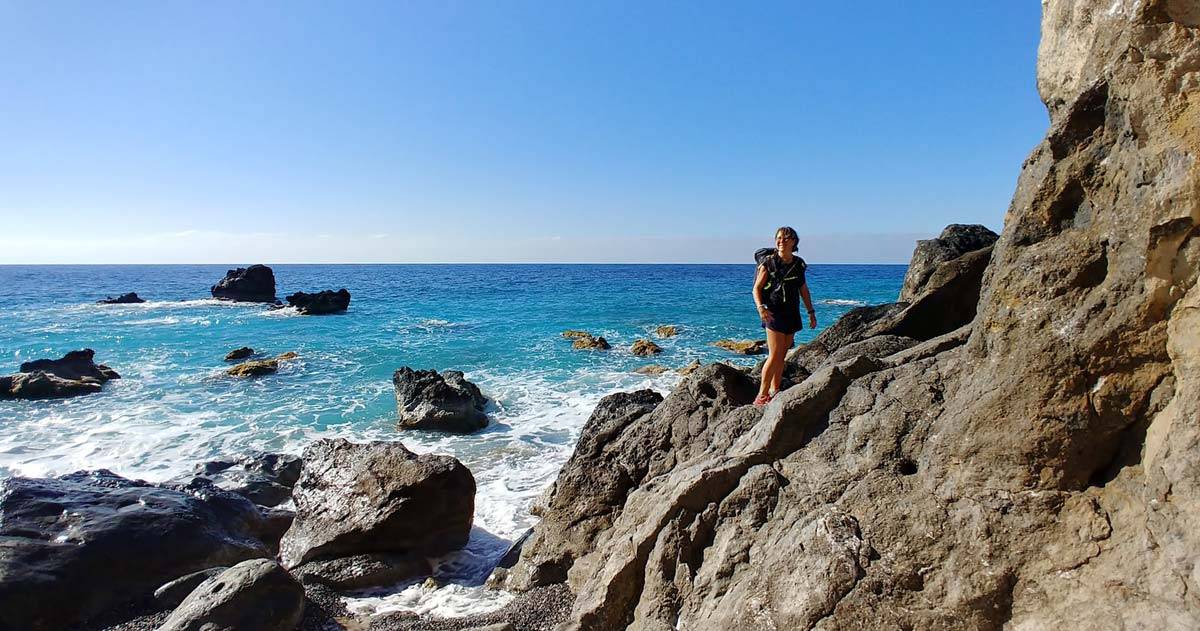
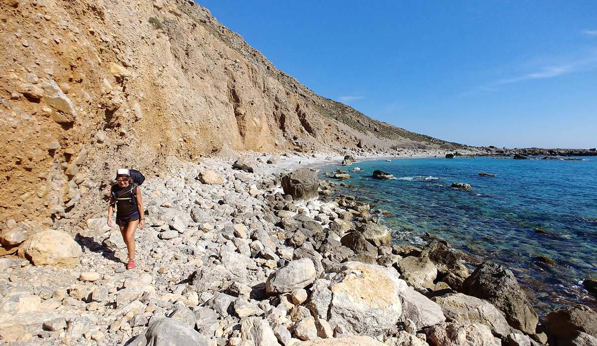
Finally, a few days ago I ran the entire route again. This time in a two-person team, together with Helen. Well, almost entire route: from Chora Sfakion to Paleochora. This section is about 60 km long and has 2,500 m of elevation gain.
But, what is it about this tour that attracts me so much? Paradoxically, above all its length! In Greece, there are many amazing, often longer roads along the coast . The route around the Mani peninsula, the route along the eastern Peloponnese or along the northern shores of the Gulf of Corinth. There are also many routes on the islands. However, all of them are asphalt trails, good at most for a bicycle trip. From Chora Sfakion to Elafonisi we have almost exclusively a narrow path. No roads nearby, hardly any towns (especially out of season). A single track of this length is a complete sensation in the contemporary reality of seaside resorts, hotels, guesthouses and guarded beaches! I don’t know of any similar case.

coastal path in the mountains
The length of the route has several fairly obvious consequences. It cannot be fully remembered. Even when you run it again, it still surprises you with news. When you run it for the first time, the amount of the world to discover is simply amazing. The route is so long (and technically difficult) that if you do not have the longest day of the year at your disposal and you are not a national elite sportsman, you will not run it in one day. And this makes every attempt to overcome it an expedition.
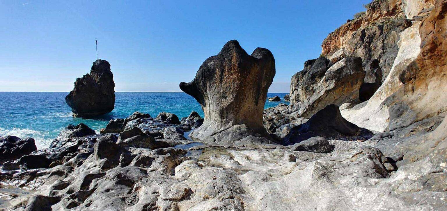
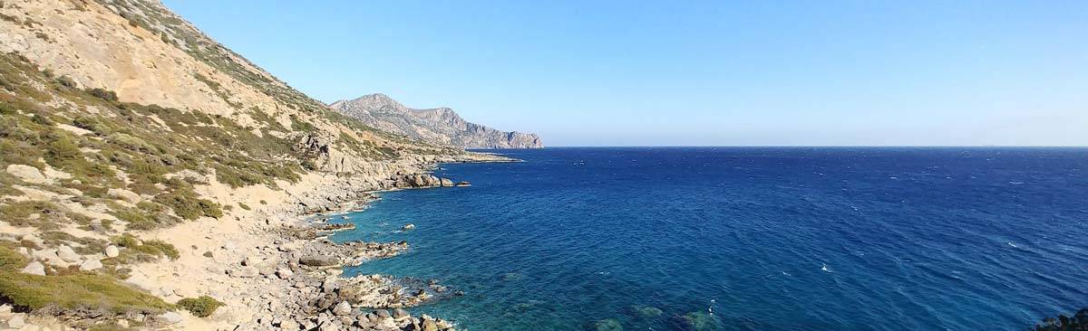
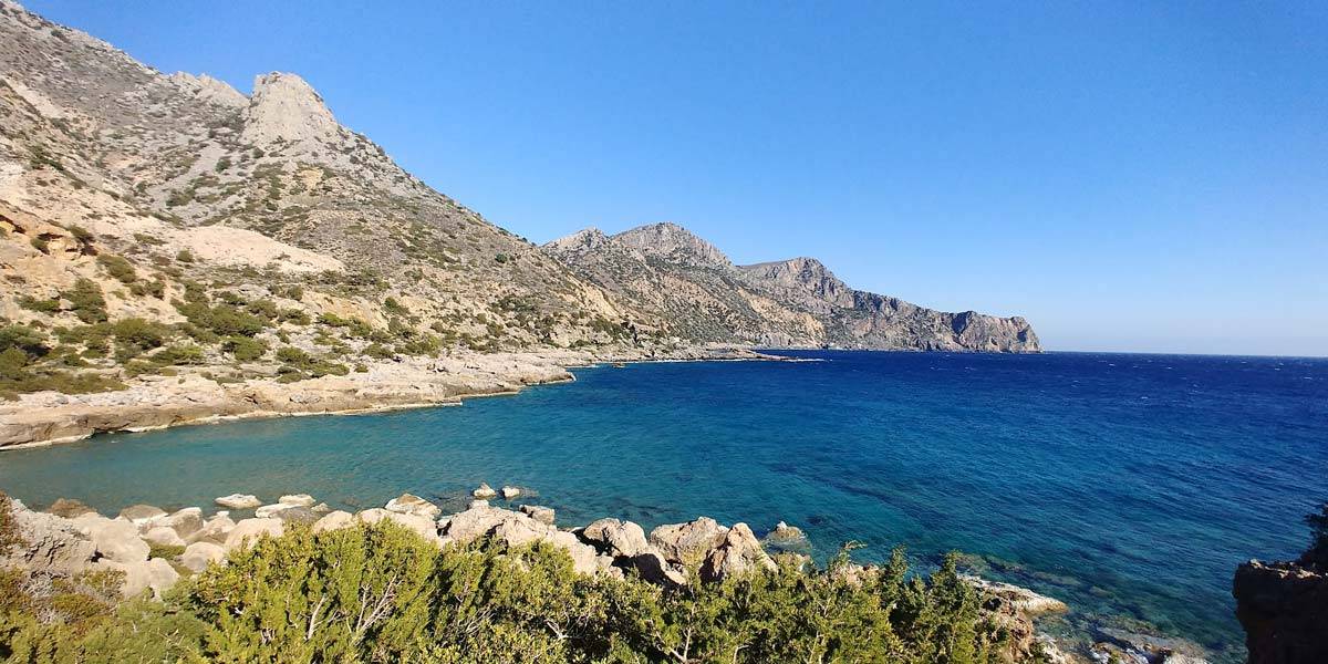
Okay, but what exactly is this route? What does she look like? What’s so delightful about it? A good short description can be the following sentence: the E-4 route from Chora Sfakion to Elafonisi is a coastal path that runs through the mountains. These two elements are crucial here – the mountains and the sea. Actually, we run by the sea all the time, you can always see it on the left side, but at the same time we are rarely on the beach itself. Of course, there are beaches, even a dozen or so, but in the whole route they constitute a small percentage – the only flat places in the sea of mountains.
The dominant feeling is that we are suspended somewhere between the mountains and the sea all the time.
And the mountains are really huge there. They grow straight out of the water and reach over 2,500 m in height (Pachnes). At the same time, the highest peak of Lefka Ori, the White Mountains – as they are called, is less than 8 km away from the coast in a straight line. Of course, the edge path does not rise so high, the highest point on the route reaches just over 500 m. Nevertheless, the route is very mountainous, we always have either an ascent or a descent.

However, this vertical opposition: mountains – sea is not everything. It obviously turns into a triad. After all, we are in the Mediterranean domain – between the mountains and the sea, but under the sky. This triad also determines the dominant colors: the incredibly clear blue of the sky, the deep emerald green of the sea and the white rocks of the mountains. There is, of course, also the greenery of trees and plants, very vivid even in winter. I don’t know what causes this unique blue sky, maybe the latitude, after all, we are extremely close to the equator. The emerald shade of the water is certainly due to the height at which we are located, the sea always achieves exceptionally intense colors when we look at it from above. Against this background, the whiteness of the rocks appears even whiter, although the high limestone content may also play a role.
what is on the other side?
To this vertical triad, of course, there is the horizontal dimension – the entire route is an endless number of peninsulas and bays. You can probably count them, but the route is so long that you quickly lose count. So we run uphill when we cross a peninsula and run down when approaching next bay. And because it is repeated so many times, following this route is a kind of meditation in motion. I also have the impression that the E-4 path in the south of Crete reveals to us one of the deepest secrets of running / walking in the mountains. We run to the top to see what’s on the other side! And if such a desire really drives our will to exist, in the south of Crete it finds multiple fulfillment. The sequence bay – peninsula is repeated with amazing consistency, but the view from above on the next bay is different each time. This tour reveals the richness of the world in an exceptionally accurate and exceptionally attractive way.
But that’s not all. This path is also a great promise. Running along the coast, we have a big number of gorges on the right side. Sometimes we don’t even realize that we are passing the mouth of such a gorge. However, most of them are easily visible and recognizable – they are the lowest-lying places on the route. And each such gorge is like an invitation to go deep into the White Mountains and start another adventure. Path E-4 is also the gateway to the interior of Crete.
Peloponnese

READ MORE
Agia Roumeli and all day running
When I was running the route with Helen a few days ago, we decided to split the adventure into two days. In theory, for a very practical reason to save energy and reduce the risk of moving around at night. But when on the second day we took off a few minutes after 5 am from Agia Roumeli, I realized that the real reason was the desire to spend the whole day on the route. Or rather, a day plus a bit of night.
At five in the morning in February in Crete it is still completely dark. After Agia Roumeli the most difficult, least known, but now I know that the most beautiful section of the entire passage begins. It starts with the biggest approach – 500 meters up from the beach, through a forest with a thousand bends, less and less visible the higher we climbed. Firstly because fewer and fewer people reach so high, and secondary a huge amount of rocks rolls onto the path in winter, making navigation difficult . There are steep cliffs in this section, the route runs close to the edge several times, there are even permanently installed lifelines for people less resistant to the abyss.
Watching all this in the light of the headlamps was an additional amazing experience. Such light from the lamp on the head brings out only fragments of reality from nothingness. The eyesight focuses on what is clearly visible, slightly registering what is barely visible a little further and guessing only what is somewhere beyond the limits of light. However, on a larger scale, there is much more to see. The horizon is already visible, the outline of the mountains in all directions can be seen and the sky shines more and more in the east, announcing the arrival of day. Watching how the day is born, it is getting brighter and warmer, the world is almost completely red for a moment, then it takes on the most intense colors, it comes noon and reality fades a bit, although in February there is rather no heat, after a few hours dusk is approaching and the spectacle with red is repeated, and we are still running through successive bays and peninsulas added the third, time dimension to the horizontal-vertical duo.
I was deeply convinced that time flowed differently that day. It was so dense that it could be cut with a knife. Is it any wonder that I don't stop thinking about it, I still want to go back there and experience everything anew?
Crocodile Trail
In the process of writing this text, I was again on my path of dreams. I ran the final stretch from Sugia to Paleochora during the Crocodile Trail competition. At a completely crazy pace – as in competitions – but with no less satisfaction and rediscovery that even the most technically difficult path can be run fast. It even seems easier, because most of the obstacles are simply jumped over. And I’m already planning my next trips to these areas – whether it’s a fast-paced one-day run, or a bigger trip to the mountains when the E-4 coastal route will be just a part of a larger whole. Because it seems that everything in Crete begins and ends on the southern path along the coast of the Libyan Sea.
The path of my dreams never ceases to fascinate me.

Maleas to Astros

READ MORE
some practical remarks
The route from Chora Sfakion to Elafonisi is part of the international tourist route E-4 marked in the field with yellow signs (sometimes hardly visible). The total length of this section is about 75 km, elevation gain 2700 m. But since nothing in the world is absolutely perfect, the tour has a flaw. From Paleochora to the village of Kiros you have to run on asphalt. It’s about 8 km. Unfortunately, this section cannot be overcome by any path. Therefore, each expedition could end in Paleochora and describe the entire route in this way. However, the last, 11-kilometre stretch from Kiros to Elafonisi is so attractive that it is even worth running this 8 km on asphalt.
During the tourist season, which lasts here from May 1 to October 31, the route includes the following places with water and open taverns, so you can eat something and replenish your supplies: Chora Sfakion (beginning) – Loutro (7 km) – Agios Pavlos (17 km) – Agia Roumeli (21 km) – Sugia (40 km) – Paleochora (57 km) – Kiros (65 km) – Elafonisi (75 km – end of the route). Out of season, most of these places are completely deserted and everything is closed there (although you can usually find drinking water). Only Chora Sfakion, Sugia and Paleochora remain. It is also worth remembering that the end of the route – Elafonisi – is just a beach, there is not even an access there, the asphalt road starts several hundred meters higher and there is no public transport there in the off-season. Buses run throughout the year to Chora Sfakia, Sugia and Paleochora.
For people sensitive to temperature, it may also be valuable to know that every time I ran there in November, December or February, the temperature during the day was around 20 degrees C, and at night not lower than 12 degrees C. In the summer season it can be hot (35 degrees C) and for many people this is the biggest challenge of this route. If you are running in the middle of summer, take some more water.
Chania – Sugia- Paleochora, February 2023
Extended gallery of photos from the E-4 path you can find in my South End Gallery
Gpx files from my last crossing are here – Chora Sfakion to Ag. Roumeli and here – Ag. Roumeli to Paleochora


