Trail Running
Competition in Greece
Subjective guide
FEBRUARY 3, 2026 | CHANIA | 28 MIN
FEBRUARY 3, 2026 | CHANIA | 28 MIN
Running
Competition in Greece
Subjective guide
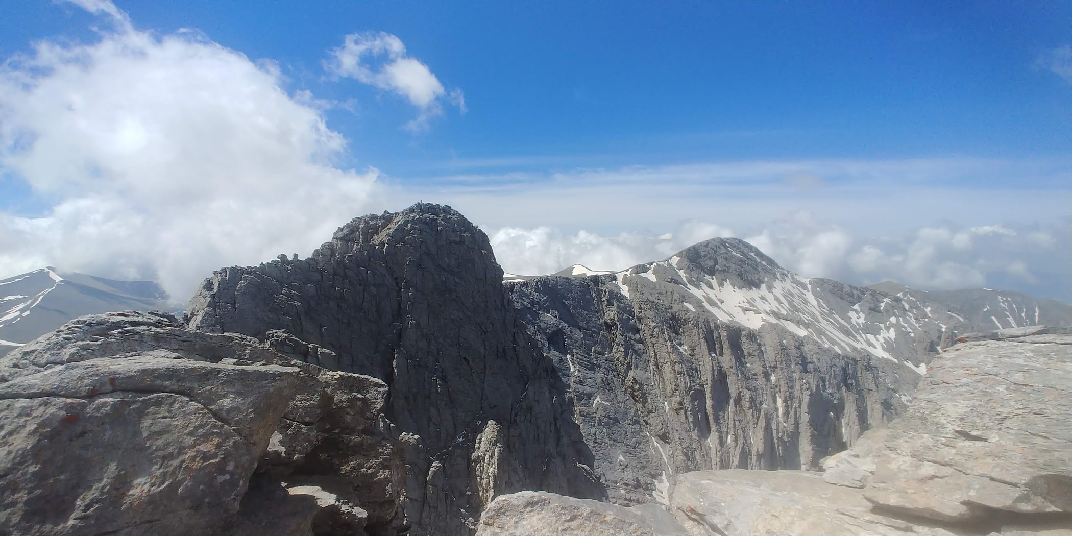
View from the summit of Pachnes to the East. Lefka Ori, Crete.
I have been living in Greece for several years. I had competed in a mountain running competitions more than 100 times. This is my little guide. Below I present an overview of the most important Greek mountain runs, but only those in which I participated, or at least I know the route, because I ran it outside the competition (two such cases). The overview includes basic information and a short description, and in some cases there is also a link to an extensive report that can be found on the website.

ABOUT RUNNING IN THE GREEK MOUNTAINS
82% of Greece’s land area is mountains! Mostly wild and difficult to access, little known to tourists, with a limited number of roads and paths. These are generally higher ranges than in Poland and mostly rocky (although they do not resemble our Tatra Mountains at all). For a runner, it manifests itself in the fact that the vast majority of paths are very rocky, so the technical difficulty of the routes is much greater than in our country. Nevertheless, the Greek mountains are very diverse: the relatively moist, deciduous forests in the Rhodope Mountains in the north of the country are nothing like the dry and treeless areas of the islands.
Due to the very expansive nature and routes not frequented by tourists, the most important element of competition preparation in Greece is cleaning the routes. Each organizer spends a lot of time on this – cleaning and cutting the brush; otherwise the route would be almost impossible to cross. There are also cases where, for the purposes of the competition, the organizer builds paths from the beginning or restores routes that have not been used for decades. Greece is a true terra incognita of mountain runners.
Do not be afraid of the heat during Greek competitions – it is always cooler in the mountains, and the island runs (usually at lower altitudes) are organized in spring or autumn when the temperatures are moderate.
Polish lovers of mud baths will be disappointed – there is no mud in Greece. Nowhere!
It is also worth mentioning that despite the smaller number of mountain running competitions than in Poland, the HARTA organization was established on the Aegean Sea, bringing together organizers and runners, with its own system of assessing the achievements of competitors during competitions or training. It is a system similar to the ITRA system, but in an open formula, i.e. anyone can enter their training parameters at any time on a dedicated website and check their score.
And below is an overview of the most important trail events in Greece, divided by regions. I only describe the competition in which I took part (over 100 starts) or I know their route because I did it outside the competition. In a few cases, there are links to extensive reviews on the website.
COMPETITIONS AT THE OLYMPUS
The Olympus massif is almost as big as the whole Tatra Mountains. We are only talking about the main part of the massif, because Olympus flows smoothly into the Pieria Mountains in the north and the Lower Olympus massif in the south. Olympus is also the place where the Greek mountain running was born – the first competition was held here in 1986 (still organized), it is also the place where the selection of runs is the greatest. Annually, at the Mountain of Gods, at least 10 different events are organized, many with different distances to choose from. However, none of the routes of this competition runs through the highest peak – Mitikas (it is difficult to climb, requires some climbing skills), but two routes run up the second highest peak – Skolio (2,913 m above sea level). So you run high on Olympus, to a great extent above 2,000 m. The routes are very diverse: at the bottom, in the layer of dense, powerful forests, there are plenty of soft paths, while stones in various versions prevail above, both movable and razor-sharp, as well as more round. You will also find paths with wooden steps on Olympus, but since these steps have not been renovated for 40 years, their current condition is deplorable, which makes these parts of the trails one of the most technically difficult routes in Greece.

Olympus Mythical Trail
Distance: 110 km.
Elevation gain: +7200/-7200 m.
Date: Not organized in 2026.
Additional distances: none.
Start/finish: Litochoro.

Rogkas
Distance: 41 km.
Elevation gain: +3450/-3450 m.
Date: 25.01.2025
Additional distances: no info yet.
Start/finish: Litochoro.
Winter competition on Olympus. Winter in the case of Greece means that the chances of snow are small (although this year 1/4 of the route was covered with snow), and the temperature may be 10-15 degrees C. The route is perfectly configured, full of interesting ascents and long and very fast downhills. Forest paths, mostly soft, with few rocks (except the last descent which is super rocky!).

Gulag 100
Distance: 167 km.
Elevation gain: +14260/-14260 m.
Date: unknown
Additional distance: 33 km, +2870 m.
Start/finish: Ag. Ioanis/Litochoro
Worldwide unique competitions. The numbers speak for themselves, this is not a mistake, the elevation gain is over 14,000. meters! The route consists of 5 loops of 33 km, each subsequent one covered in the opposite direction. In addition, there are two powerful and steep ascents along the way, one with a difference in level of 1000 m (over a distance of 5 km), the other 700 m. The limit of 48 hours to complete the entire route means that it is an extremely difficult competition. No wonder that during the two editions held so far, only 4 competitors (in total) reached the finish line!
Goumarostali Vetical Mile
Distance: 4,7 km.
Elevation gain: +1520m
Date: Unknown.
Additional distances: none.
Start: Prionia/Litochoro, finish: Muses Plateau.
The world’s only (!) One mile vertical competition. There are many vertical kilometer competitions, but ITRA only scores one vertical mile. To say the route is steep is to say nothing. At first through the forest, then all the time along a sharp ridge, with chasms on both sides. At the end there is also a part of real rock climbing (but secured with a rope).
Olympus Marathon
Distance: 44 km.
Elevation gain: +3350/-3000 m.
Date: 26-28.06.2026.
Additional distances: Olympus Ultra 70 km; Kopsi ton Aeton 14 km; Melindra Trail 5 km; Olympus Vertical 4,25 km +1000 m
Start: Dion, finish: Litochoro.
The most prestigious and most international Greek competition. The best Greek runners always starts there, often also very good foreign participants. The entire first half of the route (20 km) is one great ascent from sea level to the Plateau of Muses (approx. 2600 m up). Then there is a breakneck and technically hellish descent, and finally a no less difficult “flat” section (continuous descents and ascents, although relatively short). Noteworthy is also the longer distance (which is treated as less important), leading in part along much less known, but beautiful, paths.
Lost Trail
Distance: 57 km.
Elevation gain: +4200/-4200 m.
Date: Not organized anymore
Additional distances: none.
Start/finish: Litochoro.
The competition is held in autumn on the eastern slopes of Mount Olympus, with the start and finish in Litochoro. The route is full of beautiful forest single tracks, it rises to a maximum height of 2,100 m (i.e. low for Olympus), so it is relatively technically easy and mostly runnable. There is also no danger of heat in September and the weather is usually very favorable.
Karya Olympus Trail
Distance: 25 km.
Elevation gain: +1500/-1500 m.
Date: May 31, 2026.
Additional distances: 9 km.
Start/finish: Karya.
The competition takes place on the southern, much less forested slopes of Mount Olympus. For this reason, the route is full of beautiful views and open spaces. Interestingly, for the purposes of the competition, the local organizers built almost the entire route from scratch or brought back to life paths that had not been used for a long time. Thanks to this, the competitors have the opportunity to run on routes specially prepared for running (a huge number of bends is, for example, properly profiled). Start and finish in a small village lost among the mountains.

Faethon Sky Race
Distance: 25 km.
Elevation gain: +1800/-1800 m.
Date: 13.07.2025.
Additional distances: 14 km
Start/finish: Kokkinopilos.
The competition, which had a marathon distance until the previous year, was shortened this year to 25 km. The route follows rarely traveled “paths” in the western part of Mount Olympus. The paths are in quotation marks, because for a large part of the route there is no path, you just run on stones, although the route is well marked, with signs permanently painted on the stones. Start and finish in the traditional village of Kokkinopilos at an altitude of 1000 m.

COMPETITIONS IN THE PINDOS MOUNTAINS
Zagori TeRA
Distance: 60 km.
Elevation gain: +4290/-4290 m.
Date: 17-19.07.2026.
Additional distances: 33 km, +2100m; 21 km, +1170 m; 10 km, +430 m.
Start/finish: Tsepelovo.
A competition held in Western Greece, among the beautiful landscapes of the Pindos Mountains. Zagori is a word of Slavic origin and means the land “behind the mountains”. The route leads, among others the bottom of one of the deepest gorges in Europe – Vicos, with white walls up to 1200 m high. The villages passed along the way are also unusual, with perfectly preserved traditional architecture and stone roads: Papingo, Monodendri or Kapesovo.
Tihio Race
Distance: 100 km. (stage race - 3 days)
Elevation gain: +5350/-5350 m.
Date: 1-3.05.2026.
Additional distances: 51 km, +2850 m; 30 km, +1530 m; 20 km, 900 m.
Start: Tihio Doridos, Fokida County, South Greece
Tihio Diskouri is a small village in the mountains of southern Greece, near the Gulf of Corinth. Surprisingly the mountains there are very green, full of leaves forests. The small village organizes several different moutain running competitions throughout the year (including Greece’s longest trail running competition – 250 km in September) and even mountain bike competitions. The stage race, which I mentioned first, is a rarity.

Naoussa Vermio Trail
Distance: 44 km.
Elevation gain: +3000/-3000 m.
Date: 12-14.09.2025.
Additional distances: 24 km, 1400 m; 10 km, +550 m;
Start/Finish: Naoussa, North Greece
The competition takes place in the Vermio Mountains in the north of Greece, among beautiful deciduous forests. Its most striking feature is the soft, super-fast tracks, perhaps the only one so comfortable among Greek competition. Start and finish in a large green park by the river, a few kilometers outside the town of Naoussa.
Karpenisi Trail
Distance: 26 km.
Elevation gain: +1860/-1860 m.
Date: 5.10.2025.
Additional distances: 13 km, +980 m; 6 km, 470 m;
Start/Finish: Megalio Chorio/Karpenisi, Central Greece
The competition takes place in the southern part of the Pindos Mountains, on the slopes of the beautiful and rocky Mount Kaliakuda. The area is sometimes called Greek Switzerland, even the valleys are quite high above sea level. The area is still difficult to access, off the beaten track of popular routes. Technically difficult paths, but the final descent to the finish line (6 km) is very fast.
URSA Trail
Distance: 40 km.
Elevation gain +2700/-2700 m.
Date: 22-24.05.2026.
Additional distances: 21 km, +1150 m; 11km, +664 m; Vertical 4,7 km, + 860 m.
Start/finish: Metsovo.
Ursa Trail is also a competition held in the Pindos Mountains, in central Greece. The area is wilder than on the Zagori routes, and there are fewer villages along the way. The routes are also a bit easier technically, with a predominance of forest trails. Until last year, the 100 km distance was also held at the end of August. Apparently it will not be organized anymore, but I believe that the organizer will change his mind. It was a beautiful tour!
Grammos Mountain Run
Distance: 21 km.
Elevation gain: +1490/-1490 m.
Date: June 14, 2026.
Additional distances: 10 km, 5 km.
Start: Plikati, Epirus
Competition in one of the most remote places in Greek mountains, on the border with Albania. Beautiful fir forests and a lot of open space with green meadows. Start and finish line in a small village Plikati.
Herkules Mountain Marathon
The Oiti Mountains are located in central Greece. They are just over 2,000 meters high, but are surrounded by much higher ranges of Parnasous, Giona and Varvousia (all above 2400m), so the views are amazing in all directions. The more that the route leads mostly through open spaces covered only with grasses. Mostly single tracks which – as for Greece – we can call fast and comfortable.
Argithea Mountain Race
Distance: 30 km.
Elevation gain: +2000/-2000 m.
Date: June 6-7, 2026.
Additional distances: 13 km, +700 m; 5 km, +100 m; Vertical +700 m
Start/Finish: Petrilo/Agrafa, Central Greece
Agrafa is the most wild and inaccessible mountains in Greece. They are located in the central part of the country, between the towns of Muzaki and Karpenisi. Argithea is a small area in the Agrafa Mountains. Soft paths predominate on the routes, even grassy ones in open areas. These are extremely mountain competitions, with a lot of elevation gain. There is not a single village on the route, but there are beautiful views, and in mid-June it is very green there.
COMPETITIONS IN CRETE
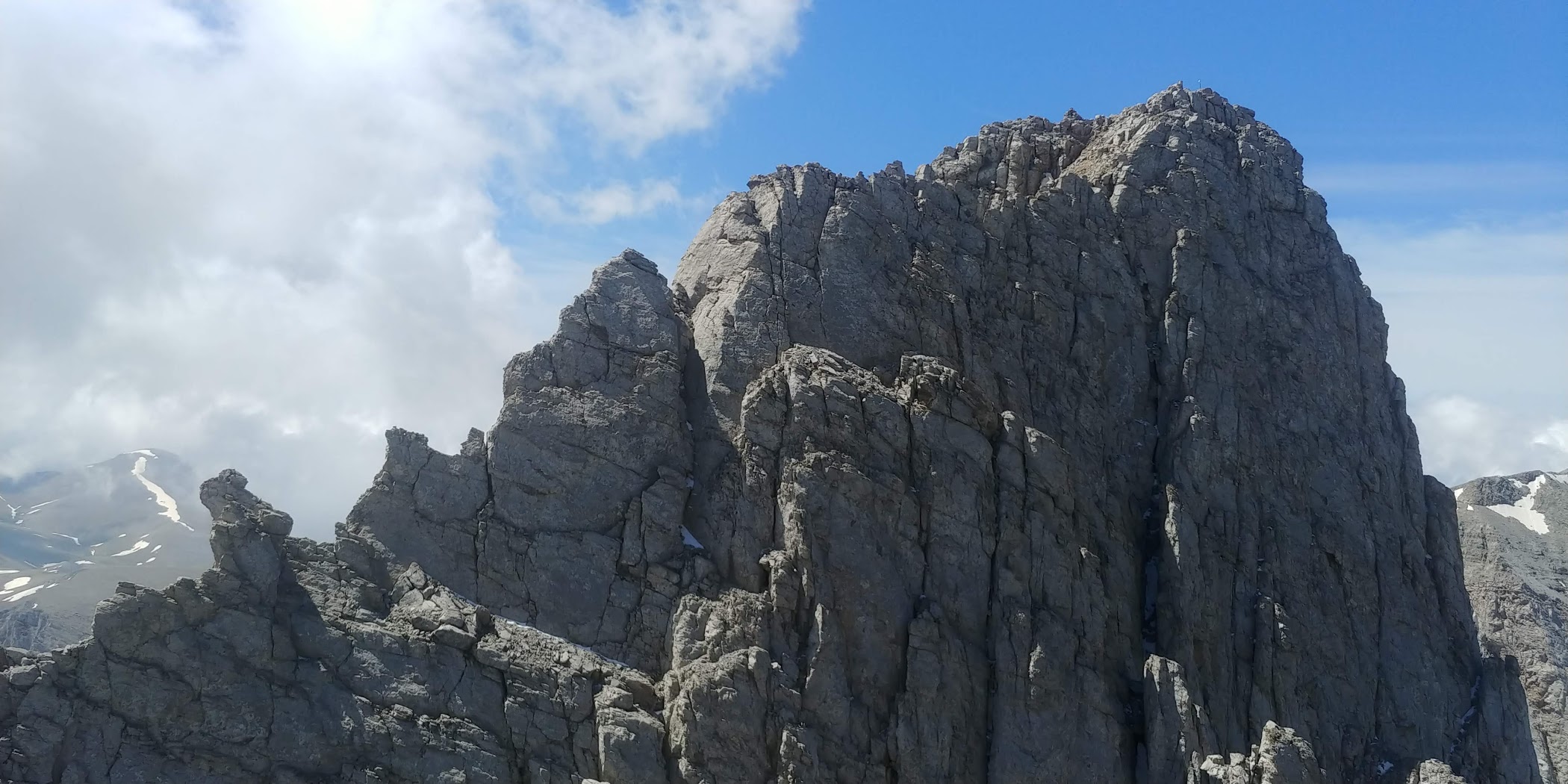
Crete is the largest of the Greek islands. It also has a large running community, to a large extent also international. Crete is, of course, very mountainous (the highest peak – Psiloritis 2456m) and has a huge number of running paths. Many of these paths are very technically difficult. Crete has the largest number of stones per linear meter of path in Greece!
The best place for running on the Island is the White Mountains (Lefka Ori) located south of the city of Chania. This place offers both incredibly difficult high-mountain paths in the area called Madara (the highest parts of the White Mountains), easier trails along lower ancient roads called kalderim (Vasilik Strada), and an extremely exciting and scenic seaside path marked as the international E-4 trail. Crete also has countless gorges (most famously the Samaria Gorge) that are great for running (especially Samaria, Agia Irini and Imbros). There are almost no forests on Crete, so all the paths are very scenic.
Quite a lot of competitions are held on Crete, and their number has even been increasing in recent years. The longest distance is still offered by the Sfakia Sky Marathon (44 km) and it seems that it would be difficult to conduct a long competition due to the extremely difficult paths.
Sfakia Sky Marathon
Distance: 44,1 km.
Elevation gain: +3050/-2480 m.
Date: 24-25.10.2026.
Additional distances: Aradena Trail 10 km +450 m; Vertical 4,9 km, +680m.
Start: Loutro, finish: Anopoli.
A completely unique competition in Crete. The competitors start from sea level (directly from the ferry) and run to the highest peak of the White Mountains – Pachnes (2453). The landscape in the area of the highest peaks (there are many of them) is completely lunar – the only such place on a European scale. There are also amazing views of the Libyan Sea with countless bays (like there is no fog, of course).

Minoiko Monopathi
Distance: 26,5 km.
Elevation gain: +1500/-1500 m.
Date: 1.03. 2026.
Additional distance: 12,5 km, +650m.
Start/finish: Mithi, Jerapetra.
Beautiful competition in the south eastern part of Crete. What makes it unique is that the route mostly runs through forests (this is an exception in Crete), so there are a lot of soft and fast paths, but there are also many dirt roads. Of course, there are beautiful views as well, because at some point the path leads along the edge of the Sarakino Gorge. Even though the route reaches an altitude of 1,200 m above sea level, at the beginning of March there is no snow there and the temperature is about 20 degrees Celsius.

Chania Trail Event
Distance: 11,3 km.
Elevation gain: +550/-550 m.
Date: 25.04.2026.
Additional distance: 6,3 km, +330m.
Start/finish: Nerokourou, Chania.
The competition will be organized for the first time in 2024, 7 km from the center of Chania. The organizer is Arkalos Team – the team responsible for organizing the Sfakia Sky Marathon competition. Chania Trail Event is a competition that is the best example of the development of the running environment in Crete. The route runs on the slopes of the steep Zourva mountain, between the villages of Nerokourou and Malaxa – this is the most important training place for mountain runners from Chania. The paths are narrow and rocky, but fast – especially since they were tidied up and cleared of stones (larger ones) for the competition.
Crocodile Trail
Distance: 20,5 km.
Elevation gain: +1200/-1200 m.
Date: 29.03. 2026.
Additional distance: 9,3 km, +337m.
Start: Sougia, finish: Paleochora.
Short, difficult and beautiful competition. The route runs largely along the coastal path, the international route E-4, on the southwestern edge of the Island. This is one of the most beautiful paths in Crete. The route is very difficult technically and is full of stones of all kinds. In addition, the most difficult climbs are at the very end. In my private ranking, the second competition in Crete after the Sfakia Sky Marathon. It’s definitely worth a try!
Sitia Geopark Trail
Distance: 24 km.
Elevation gain: +740/-1040 m
Date: 13.09.2026
Additional distances: 6 km; 3 km; children run.
Start: Pano Zakros, finish: Kato Zakros
The competition takes place in the most eastern corner of Crete. The Sitia region is almost as dry and tree-free as the White Mountains in which the Sfakia Sky Marathon is held. Start and finish on the beach, along the way one of the gorges so characteristic for Crete – Deads Gorge, technically difficult paths full of razor-sharp stones and mini plateaus situated among the mountains. Kato Zakros is also a place where one of the palaces of Minoan culture was discovered, so coming to the competition can be combined with sightseeing.
Samaria Run
Distance: 21 km.
Elevation gain: +1350/-1350 m
Date: 10.05.2026
Additional distances: 7 km;
Start/finish: Omalos
The competition takes place in the Samaria Gorge, the most famous and most spectacular of all the gorges in Crete. An additional attraction is the fact that the route leads partly along a path that is normally inaccessible to tourists. The route is not one of the most difficult in Crete, the descent into the gorge leads along a very well-maintained trail and in the second part of the distance there is even a (very fast) section on a dirt road.
The competition has the most spectacular prize-giving location: right on the edge of a deep cliff with a stunning view of the jagged, almost vertical walls of Gigilos Peak.
Retzakas Trail Run
Distance: 24,2 km.
Elevation gain: +1250/-1250 m
Date: 1.02.2026
Additional distances: 6,8 km;
Start/finish: Plokamiana
The competition takes place in the middle of the Cretan winter in the western part of the island, among low hills. The route is one of the easiest in Crete, it runs at an altitude of 500-600 m above sea level. and consists mostly of dirt roads; there are no steep climbs or too many technical parts. Midwinter in Crete means there is no snow on the route and the temperature is around 15 degrees Celsius.
COMPETITIONS ON THE OTHER ISLANDS
Greece has countless islands and quite a large number of competitions held there, which have even grown in recent years. There is clearly a desire to expand the tourist offer of these places. Most of the races on the islands are held at a distance of about 20 km, there are also shorter distances for beginners.
While the islands and the races are of course different, they all have some things in common. First of all, you can count on beautiful views. There are practically no forests on the islands, so nothing obscures the world around. From many places on the routes you can see the blue of the sea, in many cases on both sides (the islands are not large, except for Crete of course). After the competition, you can easily jump into the sea, there is always a beach nearby.
For the same reason, island runs can be combined with a family vacation. As if luck were not enough, the organizers of events on the islands are – even for Greece – exceptionally hospitable, providing many additional attractions (on Amorgos a traditional feast and regional dancing until dawn).

Hydra Trail Event
Distance: 38 km.
Elevation gain: +2000/-2000 m
Date: 4-5.04.2026
Additional distances: 18 km, +1015m; 5 km, +156 m; children run.
Start/finish: Hydra
An competition on the island with no cars. No cars means that the island is very clean, and has a huge network of hiking and running paths. Beautiful, bays, beautiful peninsulas and smaller islands all around. The most beautiful competition course I ‘ve ever seen!
Corfu Mountain Trail
Distance: 103 km.
Elevation gain: +4200/-4200 m.
Date: 2-3.05.2026.
Additional distances: 40 km, +2200m; 20 km, +1200 m; 10km, +300 m.
Start: Ipsos Port, finish: Corfu Liston
Corfu is the northernmost Greek island in the Ionian Sea. Western winds bring heavy rainfall there (much more than in Poland), therefore the island is very green; it also has a large number of olive groves, and olive trees there are exceptionally high (even 20 m). This race takes place in such conditions. Initially, the route runs through the highest mountains on the island and has beautiful narrow paths, while olive groves predominate in the second part of the route. It’s just that the roads among the olive groves are covered with asphalt or concrete. It is an ultra mountain run with the highest percentage of asphalt I have had the pleasure to participate in (something like the Polish Lemkowyna).

Amorgos Trail Challenge
Distance: 19 km.
Elevation gain: +850/-900 m.
Date: 10-11.05.2025.
Additional distances: 7,5 km, +350m; vertical; children run.
Start: Monastery of Panagia Hozoviotissa, finish: Aegiali Bay.
Amorgos is one of the islands of the Cyclades archipelago, located at its southern tip. It is famous for its beautiful colors and … the blue of the sea. Deep Blue movie was shooting there (among others). Apart from the main distance, vertical is going to be interesting, which is not exactly vertical, because you also have to run down. Only that there is no path at all, you can run upstairs and down in any way you want.

Skiathos Trail Run
Distance: 24 km.
Elevation gain: +1170/-1170 m.
Date: 24.05.2026.
Additional distances: 10 km.
Start: Skiathos, Skiathos Island
Skiathos Trail Run it is competition organized on one of Sporades Islands – this one closest to Pelion Peninsula. The island is very green, full of pine forests and quite hilly. The course consists mostly with narrow paths, but there is also some very comfortable fire roads. Because of that the course is very fast and almost all fully runnable. Skiathos town is very life and full of tourists. Beautiful beaches everywhere on the island make it attractive for family vacation and running competition as nice added value.
COMPETITIONS IN THE RODOPE MOUNTAINS
The Rhodope Mountains stretch for many kilometers on the border between Greece and Bulgaria. As for Greece, they are relatively low, because they do not exceed 2000 m above sea level. From the point of view of history, they resemble our Bieszczady Mountains – a classic area of ethnic cleansing, but much more brutal than in Poland and carried out over 100 years ago. Nevertheless, these mountains are still almost completely empty. Nature is very expansive there, eagerly seizing areas abandoned by people. Oak and beech forests in various forms predominate, but there are also rocks and deep ravines.
ROUT Classic 100 miles
Distance: 182 km.
Elevation gain: +9000/-9000 m.
Date: 16-18.10.2025.
Additional distances: none.
Start/finish: Haidou, Rodopy.
Rodopi Ultra Trail is the first 100-mile competition in Greece (but not the only one at the moment). Played as the name suggests in the Rhodope Mountains, northern Greece, close to the border with Bulgaria. In a way, the region resembles the Polish Bieszczady – it is also a historical area of ethnic cleansing (only on a larger scale than in Poland), so, similarly to the Bieszczady Mountains, it is completely empty. There is only one village on the entire route. Relatively young oak forests and soft paths predominate (a rarity in Greece), and due to the autumn season the slogan of the competition is “Hello Darkness …”

Virgin Forest Trail
Distance: 162 km.
Elevation gain: +6863/-6863 m.
Date: 10-12.10.2025.
Additional distances: 110 km +4675 m; 46 km +1930 m;
10 km.
Start/finish: Paranesti, Rodope
Competition orgenized on a very similar route to the Rodopi Ultra Trail (!), but in the opposite direction; the starting point is also different – this time a real town, as well as the beginning and end of the route. The fact that two hundred-milers are played in October, one week apart, on a very similar route, is the best proof of the popularity of this type of climates in Greece.
COMPETITIONS IN PELOPONNESE
The Peloponnese is a beautiful area of Greece with a warm climate, especially in autumn and spring, and lots of mountains. It is also a quiet area, without mass tourism, in many places it is easy to find traditional stone architecture, and the southernmost peninsula of Tenaro can confidently compete in the competition for the most beautiful place on the Aegean Sea. So far there aren’t many mountain running competitions going on there. The Taygetos Challenge is a notable exception, for many years it has been an event famous all over Greece and certainly worth recommending.
Taygetos Challenge
Distance: 40 km.
Elevation gain: +2550/-2550 m.
Date: 21-22.03.2026.
Additional distances: 20 km, +1089 m; 10 km, +460; Vertical 0,650 km +150 m.
Start/finish: Kardamili
The competition takes place in the western part of the Peloponnese, in the heart of the historic Mani land – famous for its gray stone architecture and the so-called residential towers. The starting point – the village of Kardamili is beautifully situated in a coastal valley surrounded by the Tajget Mountains. The route runs initially through olive groves, then through mixed forests. There are also some old villages along the way. A dozen or so kilometers before the finish line is a continuous downhill, with the Mediterranean Sea on the horizon.

Artemisio Mountain Running
Distance: 26 km.
Elevation gain: +1600/-1600 m.
Date: 7.12.2025.
Additional distance: 12 km.
Start/finish: Karia, Argolid.
The second competition worth recommending in the Peloponnese. Held in early December, but it’s still fall in the south of Greece, the chances of snowing are minimal. The highest point of the route is over 1700 m high, it is a bit rocky, so for a short distance the route resembles sky running. For the most part, however, it is relatively easy technically.
COMPETITIONS ON THE PELION PENINSULA
The Pelion peninsula is located in central Greece, near the city of Volos, almost halfway between Thessaloniki and Athens. There are huge expanses of deciduous forests, of course mountains (1700 m), but also large amounts of fruit orchards and olive groves. Traditional irrigation systems (using narrow stone channels) make it very green – especially in spring. One of the two narrow-gauge railways in operation in Greece (see here) is a tourist attraction. The land is also known for many dark myths, mainly about centaurs, i.e. half-humans, half-horses.

Ultra Trail Pelion
Distance: 24 km.
Elevation gain: +1150/-1150 m.
Date: 28.09.2024.
Additional distances: Due to the destruction of paths and roads in the mountains after heavy rainfall in the autumn of 2023, only the 20 km distance will be held.
Start/finish: Portaria-Makrinitsa.
The competition takes place in the northern part of the Pelion Peninsula, at the end of November, so it can be a bit dark indeed, and sometimes also cold. The trails are mostly soft forest paths, full of leaves at this time of the year. The route runs through both medium-sized mountains (1,400 m) and seaside beaches. In the vicinity of the villages there are huge amounts of oranges, apples (already slightly overripe) and olives.
Kentavros Trail Pelion
Distance: 42,2 km.
Elevation gain: +1417/-1417 m.
Date: JUNE 2024.
Additional distances: 23,5 km, 6 km
Start/finish: Agria.
In June, the Pelion Peninsula is still very green. Apart from the Tihio Race, it is the greenest route I have ever run. The beautiful, narrow paths are a great attraction, but along the way there are many charming towns with traditional architecture. The race route begins and ends in the seaside tourist village of Agria, a few kilometers south of the town of Volos.
MORE POSTS ABOUT CRETE
South End Gallery
Photos from E-4 long distance trail in south-western Crete
The Path of Your Dreams
Lefka Ori
YOU MAY ALSO LIKE
Olympus Mythical Trail. Celebrating the Heat
Out of many Greek inventions, sport probably made the biggest career. Almost nobody practices philosophy anymore, almost nobody values science, but sport is on top. Of course, this and that have changed since the first Olympic Games, but the main principles have remained the same: noble competition, „swifter, higher, stronger”.
READ MORE
My Life in Litochoro
Litochoro is attached to the edge of the cliff. The Enipeas Gorge, which is cutting the Olympus massif in half, falls almost vertically next to the last houses in the city. It is true that the buildings with taverns are even at the bottom of the gorge, but no one lives there permanently. Litochoro also has an amazingly unique layout. The main street, rising gently upwards, is located completely on the side…
READ MORE

The Path of Your Dreams. From Chora Sfakion to Elafonisi Beach
READ MORE